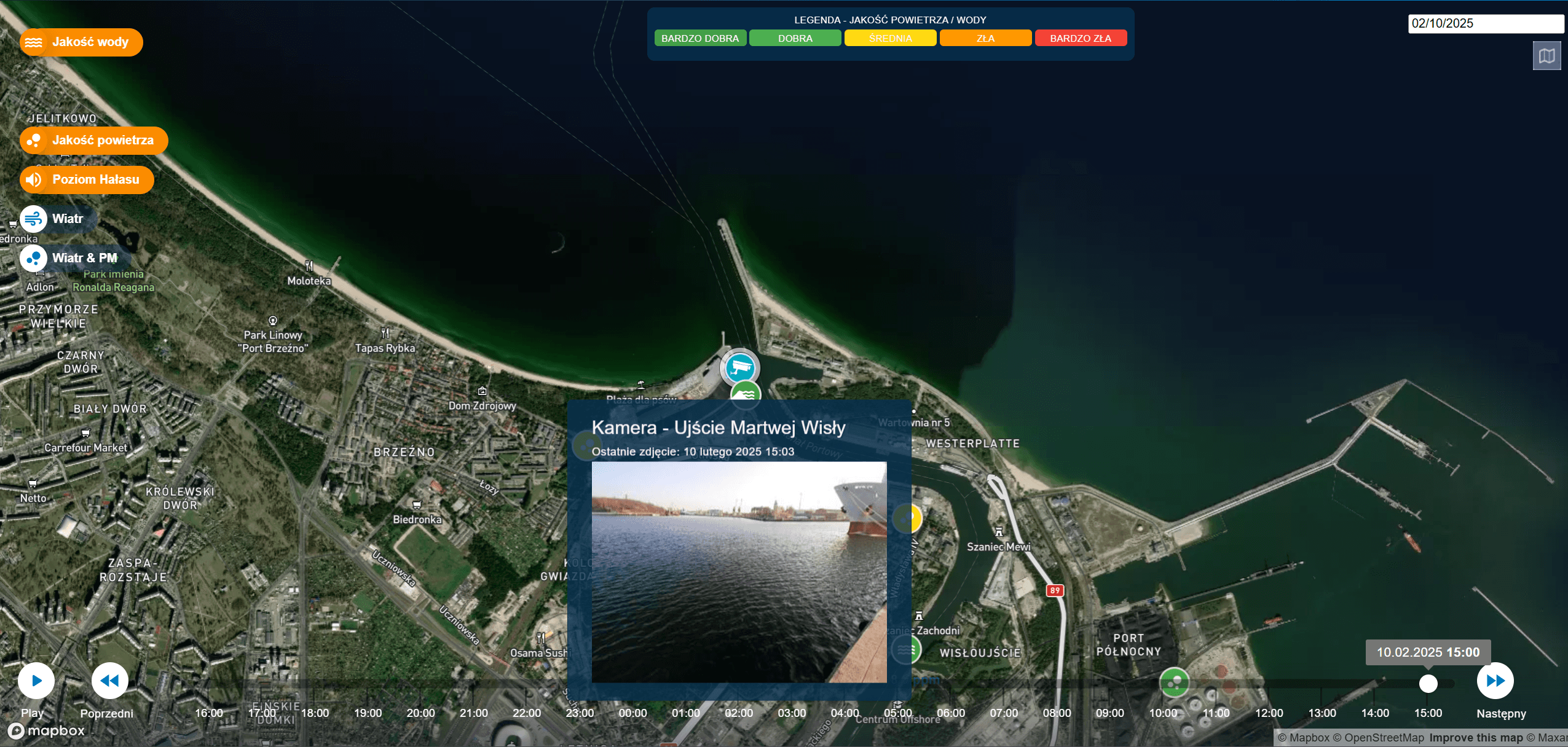
Water Quality Monitoring
(Headquartered in Gdańsk)


Water Quality Monitoring
(Headquartered in Gdańsk)
Water Quality Monitoring
(Headquartered in Gdańsk)

{01} — technology and tools
Autonomous Water Surveillance System
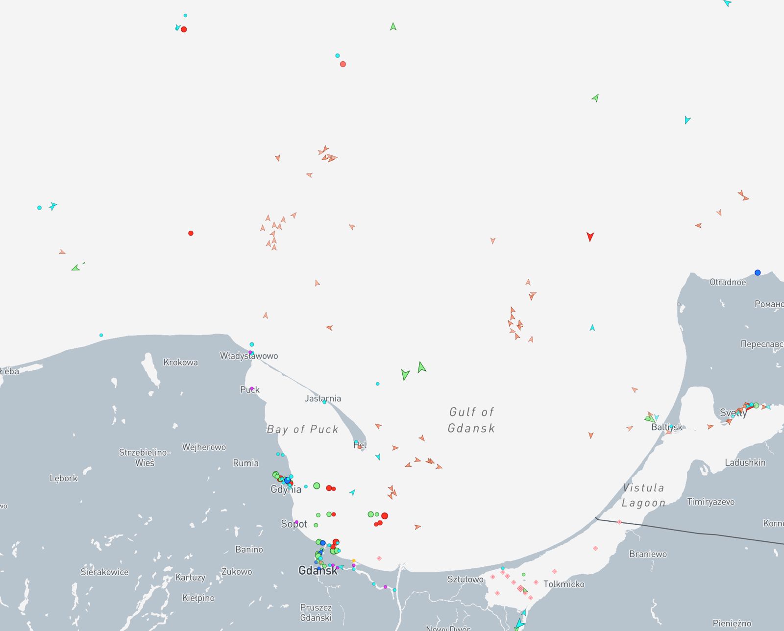
Our solution is an advanced water body monitoring system, available in both mobile (floating buoy) and stationary versions (coastal, quay installations, or on platforms). Equipped with RGB and IR cameras, a suite of sensors, and communication modules, the system operates fully autonomously and leverages artificial intelligence for real-time image analysis.
{02} — Technology and Tools
The system integrates data from external sources, such as:
{02} — Technology and Tools
The system integrates data from external sources, such as:
{02} — Technology and Tools
The system integrates data from external sources, such as:

Satellite and meteorological data
for early detection of environmental changes.
Satellite and meteorological data
for early detection of environmental changes.
Satellite and meteorological data
for early detection of environmental changes.

Automatic Identification System (AIS)
to identify vessels and detect those not transmitting signals.
Automatic Identification System (AIS)
to identify vessels and detect those not transmitting signals.
Automatic Identification System (AIS)
to identify vessels and detect those not transmitting signals.

GIS databases and protected area maps
assisting with contextual analysis.
GIS databases and protected area maps
assisting with contextual analysis.
GIS databases and protected area maps
assisting with contextual analysis.
Who is it for?
By integrating advanced cameras with AI-driven image analysis and customized surveillance systems, we have created a comprehensive platform for environmental monitoring and safety.

Port and maritime administrations
Automated systems for waterfront surveillance, vessel identification, and real-time incident analysis.
01
Port and maritime administrations
Automated systems for waterfront surveillance, vessel identification, and real-time incident analysis.
01
Port and maritime administrations
Automated systems for waterfront surveillance, vessel identification, and real-time incident analysis.
01

Border guard, navy, security services
Enhance patrol and preventive operations with intelligent threat recognition.
02
Border guard, navy, security services
Enhance patrol and preventive operations with intelligent threat recognition.
02
Border guard, navy, security services
Enhance patrol and preventive operations with intelligent threat recognition.
02
Transportation, shipping, and offshore companies
Systems that enhance operational safety and conduct inspections without the need for physical presence.
04
Transportation, shipping, and offshore companies
Systems that enhance operational safety and conduct inspections without the need for physical presence.
04
Transportation, shipping, and offshore companies
Systems that enhance operational safety and conduct inspections without the need for physical presence.
04
Environmental and ecological institutions
Monitoring pollution and activity on bodies of water using image analysis and geospatial data.
03
Environmental and ecological institutions
Monitoring pollution and activity on bodies of water using image analysis and geospatial data.
03
Environmental and ecological institutions
Monitoring pollution and activity on bodies of water using image analysis and geospatial data.
03

Insurance companies
Documentation and analysis of incidents in ports and on waterways—streamlining damage resolution and risk assessment.
05
Insurance companies
Documentation and analysis of incidents in ports and on waterways—streamlining damage resolution and risk assessment.
05
Insurance companies
Documentation and analysis of incidents in ports and on waterways—streamlining damage resolution and risk assessment.
05

Research and academic institutions
Leveraging visual data and AI for research on unit movement, environment, and safety.
06
Research and academic institutions
Leveraging visual data and AI for research on unit movement, environment, and safety.
06
Research and academic institutions
Leveraging visual data and AI for research on unit movement, environment, and safety.
06

{03}
Example Applications:
Advanced Monitoring Solutions
/
01
Maritime Border and Territorial Waters Surveillance
Border Protection:
Detection of Unauthorized Unit Movement
Advanced Monitoring Solutions
/
01
Maritime Border and Territorial Waters Surveillance
Border Protection:
Detection of Unauthorized Unit Movement
within 3 to 5 weeks
Advanced Monitoring Solutions
/
01
Maritime Border and Territorial Waters Surveillance
Border Protection:
Detection of Unauthorized Unit Movement
Safety and Security Solutions
/
02
Protection of Ports and Critical Infrastructure
Risk Identification:
Threat monitoring in strategic areas
Safety and Security Solutions
/
02
Protection of Ports and Critical Infrastructure
Risk Identification:
Threat monitoring in strategic areas
Safety and Security Solutions
/
02
Protection of Ports and Critical Infrastructure
Risk Identification:
Threat monitoring in strategic areas
Unauthorized Activity
/
03
Detecting Illegal Fishing and Smuggling
Activity Detection:
Automated detection of leaks, man overboard (MOB) incidents, and storm waves
Unauthorized Activity
/
03
Detecting Illegal Fishing and Smuggling
Activity Detection:
Automated detection of leaks, man overboard (MOB) incidents, and storm waves
Unauthorized Activity
/
03
Detecting Illegal Fishing and Smuggling
Activity Detection:
Automated detection of leaks, man overboard (MOB) incidents, and storm waves
Environmental Monitoring
/
04
Weather and Environmental Anomaly Detection
Incident Notifications:
Compliance with environmental standards
Environmental Monitoring
/
04
Weather and Environmental Anomaly Detection
Incident Notifications:
Compliance with environmental standards
Environmental Monitoring
/
04
Weather and Environmental Anomaly Detection
Incident Notifications:
Compliance with environmental standards
Preservation
/
05
Ecosystem and Reserve Monitoring
Eco Monitoring:
Protection of High-Value Natural Areas
Preservation
/
05
Ecosystem and Reserve Monitoring
Eco Monitoring:
Protection of High-Value Natural Areas
Preservation
/
05
Ecosystem and Reserve Monitoring
Eco Monitoring:
Protection of High-Value Natural Areas
Emergency Response
/
06
Support for Search and Rescue and Maritime Safety Operations
Real-Time Monitoring:
Locating Individuals in Distress
Emergency Response
/
06
Support for Search and Rescue and Maritime Safety Operations
Real-Time Monitoring:
Locating Individuals in Distress
Emergency Response
/
06
Support for Search and Rescue and Maritime Safety Operations
Real-Time Monitoring:
Locating Individuals in Distress
Comprehensive Risk Management Solutions
/
07
Risk Assessment and Support for Marine Insurance
Risk Assessments:
Event documentation for insurance analysis
Comprehensive Risk Management Solutions
/
07
Risk Assessment and Support for Marine Insurance
Risk Assessments:
Event documentation for insurance analysis
Comprehensive Risk Management Solutions
/
07
Risk Assessment and Support for Marine Insurance
Risk Assessments:
Event documentation for insurance analysis
Innovative Insights
/
08
Scientific and Oceanographic Applications
Data Acquisition:
Collecting environmental data for research
Innovative Insights
/
08
Scientific and Oceanographic Applications
Data Acquisition:
Collecting environmental data for research
Innovative Insights
/
08
Scientific and Oceanographic Applications
Data Acquisition:
Collecting environmental data for research